Around 16:00 hours on December 23rd a forecast was prepared for the next day. The period for the forecast was dawn to dusk December 24th.
Sunoptic situation:
Ridge oriented NE-SW through Thames estuary at noon with orientation becoming E-W over North Germany. Quasi stationary frontal zone Humber to South Denmark with old occlusion from Wash to Brest moving slowly to the West.
Bases:
-
10/10 fog or stratus at first bases 0-500 feet inland and 500-1,000 feet on coast with tops 1,000-1,500 feet
-
Base lifting to 500-1,000 feet inland and 800-1,200 feet on coast by 12:00 hours with cloud breaking south of 52 degrees North to nil after 13:00 hours.
-
Cloud base North of 52 degrees North becoming 1,000-1,500 feet after 13:00 hours. 3-5/10 scattered 2-3,000/6,000 feet. Over all bases.
-
Visibility: less than 500 yards inland and 500-1,000 yards on coastal bases becoming 1-2,000 yards inland but locally 500 yards and 1-3 miles on coast but locally 1,000 yards by 12:00 hours.
Target area’s:
-
Targets NW of a line through 54N08 degrees East to 52N06E to Calais: 8-10/10 fog or stratus 0-500/800-1,200 feet becoming nil 3/10 by 12:00 hours.
-
S11, SE10, 12, S13: 40-60 percent of these areas to have 10/10 st and sc 600-1,000/3-5,000 with good breaks in sheltered areas. Rest of area nil cloud.
-
Remainder of area’s: Patchy st or fog at first in valleys and industrial areas dissipating by noon. Nil cloud otherwise cpt 2-4/10 thin patchy medium and high cloud in N4 and N5.
At around 23:00 hours, December 23rd, a preliminary outlook was issued.
From Division met to met officers all Group stations. Preliminary outlook for mission of 24-12-44. Time of origin: 23:00 hours 23-12-44.
-
Bases at take-off to have 8-10/10 scattered 2,000/5,000 feet with a risk of low stratus below this 500/1,000 feet. Visibility to be variable 800-1,500 yards and locally 500 yards. On route out similar conditions to exist with low cloud becoming patchy fog over continent then breaking to nil becoming clear in the target area. Downward visibility to be poor over first part of the route becoming 15-25 miles in the target area. On return conditions to be similar with visibility becoming generally 1-2 miles in 2 BD bases but locally 1,000 yards. Patchy snow expected over first part of continent becoming continuous layer over Germany.
-
Main problem are visibility and ceilings at take-off and visibility on return. Assembly and route expected no problem from weather standpoint.
About one hour later the Division meteorology section came with an addition to the preliminary outlook.
-
It now appears that there is a good possibility of local frost before dawn. It would be a good idea to inform your ops at once.
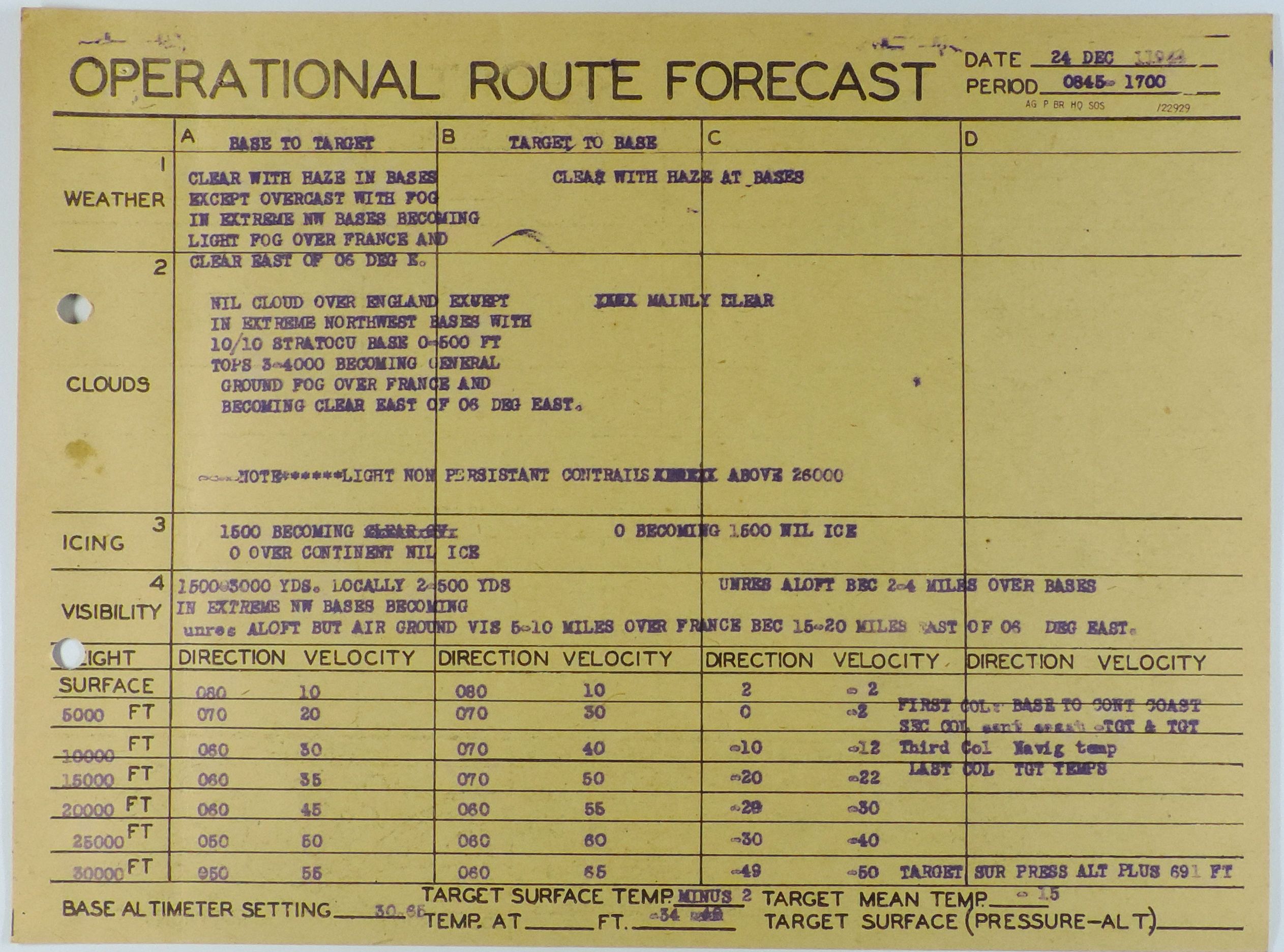
The meteorology section came with a definitive forecast the operational mission of December 24th. The period of forecast was in between 08:45-17:00 hours:
Weather aircraft.
-
Weather aircraft was dispatched by the 384th BG and flown by the Gabel and part of his crew.
-
The aircraft in question was B-17F, 42-3441 “Spotted Cow”. The following crew members were onboard:
Gabel, R.J. Pilot
Robilotta, R.F. Co-Pilot
McCarthy, R.G. Navigator
Irwin, F.X. Radio-Operator
Airhart, L.G. Engineer

Source: https://384thbombgroup.com/